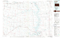
1985 Map of La Plant
USGS Topo · Published 1986About this map
The Cheyenne River Indian Reservation and Standing Rock Indian Reservation dominate this mid-1980s landscape, where the Missouri River has been transformed into the sprawling Lake Oahe. Small settlements like La Plant and Whitehorse are connected by a network of rural roads, while traces of former transportation routes appear as an Old RR Gr winding across the northern plains. The topography is defined by numerous watercourses including the Moreau River and Whitehorse Creek, which cut through the high ground marked by prominent landmarks such as Dog Butte and the Patch-Skin Buttes. Along the reservoir, recreational and community hubs emerge at the West Whitlocks State Recreation Area and the Swift Bird Training Center. Local family history is preserved at sites like Rabenberg Cemetery and the Selby Union Cem, providing fixed points for genealogical research in this prairie environment.
Find a feature on this map
98 named features on this map. Tap any name to fly to it.
Don’t see what you’re looking for? This feature index may not catch every label — zoom into the map to look around manually.
Map Details
Editions of this 1985 La Plant Map
2 editions found
Other maps of this area

1951 · Ridgeview NW
USGS Topo · 1:24,000

1951 · Virginia
USGS Topo · 1:24,000

1951 · Ridgeview NE
USGS Topo · 1:24,000

1951 · La Plant
USGS Topo · 1:24,000

1951 · Promise
USGS Topo · 1:24,000

1952 · Whitehorse
USGS Topo · 1:24,000

1952 · Trail City SW
USGS Topo · 1:24,000

1952 · Parade NE
USGS Topo · 1:24,000

1952 · Glencross SE
USGS Topo · 1:24,000

1953 · Huron
USGS Topo · 1:250,000