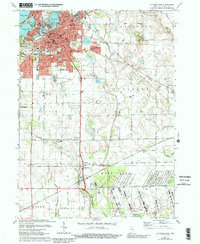
1974 Map of La Porte East
USGS Topo · Published 1991About this map
La Porte serves as a dense municipal hub in this mid-1970s survey, surrounded by a landscape defined by glacial lakes and a complex web of historic rail lines. The northern section of the city is characterized by water bodies such as Clear Lake, Lily Lake, and Stone Lake, while the urban core contains essential civic landmarks including the Courthouse, Post Office, and several parochial institutions like St John Sch and Ch. The geographic shift from the urban center to the rural townships is marked by industrial and agricultural drainage systems like Travis Ditch and Breckenridge Ditch.
Find a feature on this map
61 named features on this map. Tap any name to fly to it.
Don’t see what you’re looking for? This feature index may not catch every label — zoom into the map to look around manually.
Map Details
Editions of this 1974 La Porte East Map
3 editions found
Other maps of this area

1953 · Chicago
USGS Topo · 1:250,000

1957 · Chicago
USGS Topo · 1:250,000

1958 · Hanna
USGS Topo · 1:24,000

1958 · Kingsford Heights
USGS Topo · 1:24,000

1958 · Hamlet
USGS Topo · 1:24,000

1958 · Stillwell
USGS Topo · 1:24,000

1958 · Michigan City East
USGS Topo · 1:24,000

1958 · La Porte East
USGS Topo · 1:24,000

1958 · Springville
USGS Topo · 1:24,000

1958 · New Carlisle
USGS Topo · 1:24,000