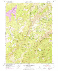
1951 Map of La Porte
USGS Topo · Published 1977About this map
Gold mining history permeates the high ridges of the Plumas National Forest and Tahoe National Forest in this mid-century survey. The landscape is defined by a dense network of placer diggings and named shafts such as the Woods Mine and Union Keystone Mine. Settlements like La Porte and Gibsonville serve as anchors along Gibsonville Ridge, while smaller sites like Port Wine, Queen City, and Howland Flat reflect the localized intensity of early California extraction.
Find a feature on this map
84 named features on this map. Tap any name to fly to it.
Don’t see what you’re looking for? This feature index may not catch every label — zoom into the map to look around manually.
Map Details
Editions of this 1951 La Porte Map
4 editions found
Other maps of this area

1888 · Bidwell Bar
USGS Topo · 1:125,000

1891 · Bidwell Bar
USGS Topo · 1:125,000

1891 · Downieville
USGS Topo · 1:125,000

1893 · Bidwell Bar
USGS Topo · 1:125,000

1893 · Downieville
USGS Topo · 1:125,000

1895 · Bidwell Bar
USGS Topo · 1:125,000

1895 · Downieville
USGS Topo · 1:125,000

1896 · Downieville
USGS Topo · 1:125,000

1897 · Bidwell Bar
USGS Topo · 1:125,000

1897 · Downieville
USGS Topo · 1:125,000