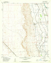
1955 Map of La Union
USGS Topo · Published 1962About this map
The Mesilla Valley defines this mid-century landscape along the New Mexico-Texas border, where a complex network of irrigation and drainage ditches supports agricultural settlements. The community of La Union sits at the center of the sheet, surrounded by named laterals such as the Deck Lateral and La Union West Lateral that manage the waters of the Rio Grande floodplain. To the north, the Refugio Colony reflects the area's early land grant history, while the southern portion transitions toward Santa Teresa and the Borderland Road. Educational and spiritual centers are well-documented, including St Lukes Ch, Central Sch, and the Gadsden Jr and Sr High Sch. The western edge of the valley is sharply defined by rising terrain, with a Southern Pacific rail line and a long-distance Telephone line cutting through the arid landscape to the west.
Find a feature on this map
27 named features on this map. Tap any name to fly to it.
Don’t see what you’re looking for? This feature index may not catch every label — zoom into the map to look around manually.
Map Details
Editions of this 1955 La Union Map
2 editions found
Other maps of this area

1891 · Las Cruces
USGS Topo · 1:125,000

1893 · Las Cruces
USGS Topo · 1:125,000

1917 · Canutillo
USGS Topo · 1:62,500

1917 · Noria
USGS Topo · 1:62,500

1918 · Noria
USGS Topo · 1:62,500

1919 · Canutillo
USGS Topo · 1:62,500

1943 · La Mesa
USGS Topo · 1:62,500

1943 · Afton
USGS Topo · 1:62,500

1953 · El Paso
USGS Topo · 1:250,000
1955 · Smeltertown
USGS Topo · 1:24,000