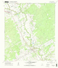
1962 Map of La Vernia
USGS Topo · Published 1963About this map
Cibolo Creek meanders through this portion of Wilson and Guadalupe counties, anchoring a landscape defined by ranching and the mid-century expansion of the petroleum industry. Near the historic community of Sutherland Springs, the extraction economy is clearly visible in the extensive Sutherland Oil Field and the nearby Linne Oil Field, while the remnants of an Old Railroad Grade trace the legacy of earlier transportation corridors. Local history is marked by essential water sources like Sulphur Spring and Denning Spring, which likely influenced early settlement patterns in the area. From the northern edges of La Vernia to the winding course of Dry Hollow Creek, this 1962 survey illustrates a rural Texas territory where traditional agriculture was increasingly punctuated by oil wells and local infrastructure like Higgins Airstrip.
Find a feature on this map
19 named features on this map. Tap any name to fly to it.
Don’t see what you’re looking for? This feature index may not catch every label — zoom into the map to look around manually.
Map Details
Editions of this 1962 La Vernia Map
2 editions found
Other maps of this area

1920 · Smiley
USGS Topo · 1:125,000

1936 · Floresville
USGS Topo · 1:62,500

1942 · Dewville
USGS Topo · 1:62,500

1953 · Seguin
USGS Topo · 1:250,000

1954 · San Antonio
USGS Topo · 1:250,000

1956 · Dewville
USGS Topo · 1:62,500

1957 · San Antonio
USGS Topo · 1:250,000

1957 · New Berlin
USGS Topo · 1:24,000

1958 · Seguin
USGS Topo · 1:250,000

1958 · La Vernia SW
USGS Topo · 1:24,000