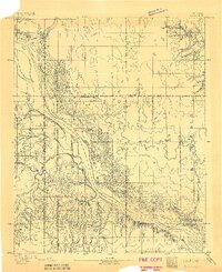
1893 Map of Lacey
USGS Topo · Published 1893About this map
The Cimarron River dominates the landscape of this 1893 Oklahoma Territory survey, carving a broad path through the central portion of the map. During this era of early settlement following the land runs, small community hubs like Lacey and Parvin began to anchor the local economy. The mapping reveals a sparse but intentional network of early infrastructure, most notably Washburns Crossing, a vital transit point over the Cimarron for travelers and local commerce.
Find a feature on this map
14 named features on this map. Tap any name to fly to it.
Don’t see what you’re looking for? This feature index may not catch every label — zoom into the map to look around manually.
Map Details
Editions of this 1893 Lacey Map
2 editions found
Other maps of this area

1892 · Kingfisher
USGS Topo · 1:125,000

1893 · Hennessey
USGS Topo · 1:62,500

1893 · Loyal
USGS Topo · 1:62,500

1893 · Ames
USGS Topo · 1:62,500

1895 · Kingfisher
USGS Topo · 1:125,000

1954 · Oklahoma City
USGS Topo · 1:250,000

1955 · Clinton
USGS Topo · 1:250,000

1955 · Enid
USGS Topo · 1:250,000

1955 · Woodward
USGS Topo · 1:250,000

1956 · Ames
USGS Topo · 1:62,500