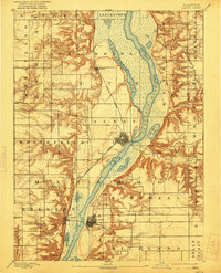
1893 Map of Lacon
USGS Topo · Published 1921About this map
The Illinois River corridor dominates this late nineteenth-century landscape, carving a wide valley filled with backwater lakes and shifting marshes. High bluffs rise sharply from the eastern and western banks, where small prairie settlements like Whitefield and Cottage Hill sit atop the plateau. The river was the primary artery of commerce and navigation, evidenced by the Lock near the grid-patterned town of Henry. Adjacent to the river, the expansive Senachwine Lake and Goose Lake reflect a time before modern drainage and levee systems significantly altered the Illinois valley bottomlands.
Find a feature on this map
37 named features on this map. Tap any name to fly to it.
Don’t see what you’re looking for? This feature index may not catch every label — zoom into the map to look around manually.
Map Details
Editions of this 1893 Lacon Map
4 editions found
Other maps of this area

1893 · Lacon
USGS Topo · 1:62,500

1893 · Hennepin
USGS Topo · 1:62,500

1893 · Metamora
USGS Topo · 1:62,500

1893 · Dunlap
USGS Topo · 1:62,500

1893 · Lasalle
USGS Topo · 1:62,500

1898 · Dunlap
USGS Topo · 1:62,500

1909 · Hennepin
USGS Topo · 1:62,500

1911 · La Salle
USGS Topo · 1:62,500

1911 · Hennepin
USGS Topo · 1:62,500

1913 · La Salle
USGS Topo · 1:62,500