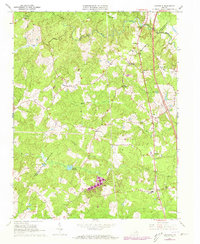
1966 Map of Ladysmith
USGS Topo · Published 1973About this map
Ladysmith sits at the intersection of local commerce and transit in Caroline County, serving as a primary hub during this mid-century period. The map documents a rural landscape defined by the winding paths of the Matta River and Mat River, where small family-named settlements like Nancy Wrights Corner, Blades Corner, and Wallers Corner mark the rural crossroads. These points of interest are accompanied by long-standing community landmarks such as Berkeley Sch, Bethany Ch, and the St Marys Cem, providing valuable data for genealogists tracing family roots through this Virginia countryside.
Find a feature on this map
29 named features on this map. Tap any name to fly to it.
Don’t see what you’re looking for? This feature index may not catch every label — zoom into the map to look around manually.
Map Details
Editions of this 1966 Ladysmith Map
4 editions found
Other maps of this area

1887 · Spottsylvania
USGS Topo · 1:125,000

1889 · Fredericksburg
USGS Topo · 1:125,000

1890 · Goochland
USGS Topo · 1:125,000

1892 · Fredericksburg
USGS Topo · 1:125,000

1892 · Spottsylvania
USGS Topo · 1:125,000

1892 · Goochland
USGS Topo · 1:125,000

1894 · Fredericksburg
USGS Topo · 1:125,000

1918 · Doswell
USGS Topo · 1:62,500

1942 · Woodford
USGS Topo · 1:31,680

1942 · Guinea
USGS Topo · 1:31,680