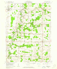
1960 Map of Lagrange
USGS Topo · Published 1963About this map
The East Branch Black River winds through the rural heart of the Connecticut Western Reserve in this early 1960s study of southern Lorain County and northern Medina County. This landscape reveals a complex network of resource extraction and transit, where numerous Oil Wells and the Preston Oil Field are interspersed among agricultural tracts. The infrastructure of the era is clearly defined by several major rail lines, including the New York Central and Baltimore and Ohio, which supported small community hubs like Lagrange and Belden.
Find a feature on this map
45 named features on this map. Tap any name to fly to it.
Don’t see what you’re looking for? This feature index may not catch every label — zoom into the map to look around manually.
Map Details
Editions of this 1960 Lagrange Map
2 editions found
Other maps of this area

1901 · Oberlin
USGS Topo · 1:62,500

1902 · Berea
USGS Topo · 1:62,500

1903 · Oberlin
USGS Topo · 1:62,500

1904 · Berea
USGS Topo · 1:62,500

1904 · Medina
USGS Topo · 1:62,500

1904 · Wellington
USGS Topo · 1:62,500

1906 · Medina
USGS Topo · 1:62,500

1906 · Wellington
USGS Topo · 1:62,500

1950 · Cleveland
USGS Topo · 1:250,000

1953 · West View
USGS Topo · 1:24,000