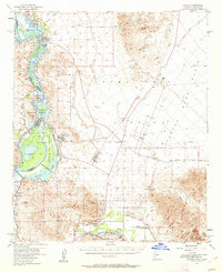
1955 Map of Laguna
USGS Topo · Published 1962About this map
Martinez and the riverfront landings along the Colorado River define this desert landscape during the mid-1950s. The survey captures a period of significant water management and military activity, with the terrain north of the Gila Mountains dominated by the Yuma Test Station. Along the river, localized settlements like Fisher Landing and Castle Dome Landing highlight the importance of water access for transportation and early habitation in this arid region. The map reflects a landscape in transition, where established river landings met the expansion of post-war military infrastructure. This documentation is grounded in 1953 aerial photography and field checks from 1955, providing a clear record of the roads, landing strips, and desert tracks that connected these remote points before more modern development altered the river's character.
Find a feature on this map
3 named features on this map. Tap any name to fly to it.
Don’t see what you’re looking for? This feature index may not catch every label — zoom into the map to look around manually.
Map Details
Editions of this 1955 Laguna Map
3 editions found
Other maps of this area

1903 · Yuma
USGS Topo · 1:125,000

1905 · Yuma
USGS Topo · 1:125,000

1926 · Fortuna
USGS Topo · 1:62,500

1926 · Wellton
USGS Topo · 1:62,500

1929 · Fortuna
USGS Topo · 1:62,500

1929 · Laguna
USGS Topo · 1:62,500

1929 · Wellton
USGS Topo · 1:62,500

1939 · Red Hill
USGS Topo · 1:62,500

1940 · Yuma
USGS Topo · 1:62,500

1942 · Yuma
USGS Topo · 1:250,000