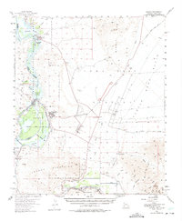
1955 Map of Laguna
USGS Topo · Published 1975About this map
Gila City and the historic Butterfield Stage Route anchor this desert landscape along the Arizona-California border during the mid-1950s. The map illustrates a complex water management and transportation network, featuring the Imperial Dam and the Gila Gravity Main Canal branching off the Colorado River. Traces of the region's mining and riverboat history are evident at the Castle Dome Landing and the Old Senator Mine, while the modern presence of the Yuma Test Station signals the area's mid-century military importance. The Southern Pacific railroad follows the path of the Gila River through the Laguna Mountains, passing through settlements like Dome and Kinter. From the Imperial National Wildlife Refuge to the Muggins Mts, the sheet documents the transition from early pioneer trails and steamship landings to contemporary irrigation and defense infrastructure.
Find a feature on this map
51 named features on this map. Tap any name to fly to it.
Don’t see what you’re looking for? This feature index may not catch every label — zoom into the map to look around manually.
Map Details
Editions of this 1955 Laguna Map
3 editions found
Other maps of this area

1903 · Yuma
USGS Topo · 1:125,000

1905 · Yuma
USGS Topo · 1:125,000

1926 · Fortuna
USGS Topo · 1:62,500

1926 · Wellton
USGS Topo · 1:62,500

1929 · Fortuna
USGS Topo · 1:62,500

1929 · Laguna
USGS Topo · 1:62,500

1929 · Wellton
USGS Topo · 1:62,500

1939 · Red Hill
USGS Topo · 1:62,500

1940 · Yuma
USGS Topo · 1:62,500

1942 · Yuma
USGS Topo · 1:250,000