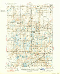
1928 Map of Laingsburg
USGS Topo · Published 1950About this map
Laingsburg sits at the heart of this central Michigan landscape, a region defined by its glacial hydrology and developing transportation corridors in the mid-1920s. The Lookingglass River and Maple River meander through the terrain, while the extensive Chandler Marsh and Chandler Ditch highlight the area's complex drainage history. The map records a dense network of local education and faith, evidenced by numerous rural schoolhouses like Octagon Sch and Jesse Sch, alongside community anchors such as Middlebury Church.
Find a feature on this map
95 named features on this map. Tap any name to fly to it.
Don’t see what you’re looking for? This feature index may not catch every label — zoom into the map to look around manually.
Map Details
Editions of this 1928 Laingsburg Map
5 editions found

Other maps of this area

1908 · Fowlerville
USGS Topo · 1:62,500

1909 · Mason
USGS Topo · 1:62,500

1910 · Fowlerville
USGS Topo · 1:62,500

1910 · Lansing
USGS Topo · 1:62,500

1911 · Mason
USGS Topo · 1:62,500

1912 · Lansing
USGS Topo · 1:62,500

1917 · Chesaning
USGS Topo · 1:62,500

1918 · Elsie
USGS Topo · 1:62,500

1918 · Perrinton
USGS Topo · 1:62,500

1926 · Corunna
USGS Topo · 1:62,500