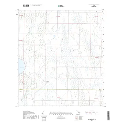
2021 Map of Lake Arbuckle NE
USGS Topo · Published 2021About this map
The MacDill Air Force Base Auxiliary Field occupies a prominent position in this landscape of central Florida, where the border of Polk and Highlands counties meets. The terrain is defined by an extensive wetland network, characterized by the expansive Blue Jordan Swamp and the slow-moving waters of Morgan Hole Cr. To the west, the eastern shoreline of Lake Arbuckle serves as a primary geographical anchor, with the Rim Canal and Arbuckle Creek providing critical drainage and navigation routes through the low-lying interior. This 2021 survey reveals a region where human infrastructure is largely confined to military utility and light recreational access, represented by the Arbuckle Creek Trail and Wainwright Way. The map provides a clear view of the Public Land Survey System township and range lines that still organize this relatively undeveloped portion of the state.
Find a feature on this map
18 named features on this map. Tap any name to fly to it.
Don’t see what you’re looking for? This feature index may not catch every label — zoom into the map to look around manually.
Map Details
Editions of this 2021 Lake Arbuckle NE Map
This is the sole edition of this map. No revisions or reprints were ever made.
Other maps of this area

1952 · Fort Kissimmee
USGS Topo · 1:24,000

1952 · Lake Weohyakapka SE
USGS Topo · 1:24,000

1952 · Lake Arbuckle SW
USGS Topo · 1:24,000

1952 · Fort Kissimmee NW
USGS Topo · 1:24,000

1952 · Lake Arbuckle NE
USGS Topo · 1:24,000

1952 · Lake Arbuckle SE
USGS Topo · 1:24,000

1952 · Lake Arbuckle
USGS Topo · 1:24,000

1952 · Lake Weohyakapka
USGS Topo · 1:24,000

1953 · Lake Marian SW
USGS Topo · 1:24,000

1956 · Fort Pierce
USGS Topo · 1:250,000