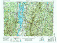
1962 Map of Lake Champlain
USGS Topo · Published 1975About this map
Lake Champlain serves as the central artery for this region, bisecting the Adirondack Mountains of New York and the Green Mountain National Forest in Vermont. During the mid-twentieth century, the area functioned as a vital corridor for both military defense and international commerce, evidenced by the large footprints of Plattsburgh AFB and Ethan Allen AFB. The transport network shows a heavy reliance on the Central Vermont Rr and Delaware & Hudson Rr to move goods between industrial centers like Burlington, Plattsburgh, and Montpelier.
Find a feature on this map
114 named features on this map. Tap any name to fly to it.
Don’t see what you’re looking for? This feature index may not catch every label — zoom into the map to look around manually.
Map Details
Editions of this 1962 Lake Champlain Map
3 editions found

Other maps of this area

1894 · Elizabethtown
USGS Topo · 1:62,500

1894 · Port Henry
USGS Topo · 1:62,500

1894 · Plattsburg
USGS Topo · 1:62,500

1894 · Ticonderoga
USGS Topo · 1:62,500

1895 · Mooers
USGS Topo · 1:62,500

1895 · Rouse Point
USGS Topo · 1:62,500

1895 · Willsboro
USGS Topo · 1:62,500

1895 · Elizabethtown
USGS Topo · 1:62,500

1895 · Mt. Marcy
USGS Topo · 1:62,500

1895 · Ausable
USGS Topo · 1:62,500