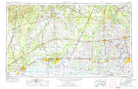
1954 Map of Lake Charles
USGS Topo · Published 1975About this map
Lake Charles anchors this mid-century portrait of Southwest Louisiana, a region defined by its intricate network of waterways and burgeoning industrial corridor. The landscape transitions from the dense timberlands of Kisatchie National Forest in the north to the expansive wetlands of the Black Marsh and the coastal Lacassine National Wildlife Refuge to the south. Major transportation arteries like Interstate 10 and long-established rail lines including the Southern Pacific and Kansas City Southern reflect the area's role as a vital transit hub between Texas and the Louisiana interior. From the agricultural plains around Crowley and Jennings to the winding course of Bayou Teche near Opelousas, the map captures the transition from bayou-based commerce to modern highway development. The proximity of Orange and Bridge City across the Sabine River highlights the interconnectedness of the border economy during this era of post-war growth.
Find a feature on this map
37 named features on this map. Tap any name to fly to it.
Don’t see what you’re looking for? This feature index may not catch every label — zoom into the map to look around manually.
Map Details
Editions of this 1954 Lake Charles Map
3 editions found

Other maps of this area

1926 · Terry
USGS Topo · 1:24,000

1926 · Lakeview
USGS Topo · 1:24,000

1926 · Vidor
USGS Topo · 1:24,000

1926 · Texla
USGS Topo · 1:24,000

1926 · Mauriceville
USGS Topo · 1:24,000

1932 · Lake Charles NE
USGS Topo · 1:31,680

1932 · Moss Lake
USGS Topo · 1:31,680

1932 · Abbeville NE
USGS Topo · 1:31,680

1932 · Beaumont
USGS Topo · 1:62,500

1932 · Lake Charles NW
USGS Topo · 1:31,680