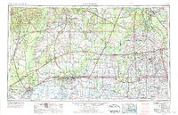
1954 Map of Lake Charles
USGS Topo · Published 1984About this map
Lake Charles serves as the focal point of this industrial and coastal survey, where the Calcasieu River meets the Intracoastal Waterway in Southwest Louisiana. The landscape is defined by the transition from the piney woods of Kisatchie National Forest in the north to the expansive wetlands of the Black Marsh and Lacassine National Wildlife Refuge near the coast. A dense network of fossil fuel infrastructure is visible, with numerous Oil and Gas Fields scattered across the prairies and marshes, particularly near Sulphur and Vinton.
Find a feature on this map
155 named features on this map. Tap any name to fly to it.
Don’t see what you’re looking for? This feature index may not catch every label — zoom into the map to look around manually.
Map Details
Editions of this 1954 Lake Charles Map
3 editions found

Other maps of this area

1926 · Terry
USGS Topo · 1:24,000

1926 · Lakeview
USGS Topo · 1:24,000

1926 · Vidor
USGS Topo · 1:24,000

1926 · Texla
USGS Topo · 1:24,000

1926 · Mauriceville
USGS Topo · 1:24,000

1932 · Lake Charles NE
USGS Topo · 1:31,680

1932 · Moss Lake
USGS Topo · 1:31,680

1932 · Abbeville NE
USGS Topo · 1:31,680

1932 · Beaumont
USGS Topo · 1:62,500

1932 · Lake Charles NW
USGS Topo · 1:31,680