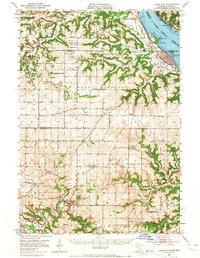
1951 Map of Lake City
USGS Topo · Published 1965About this map
Lake Pepin dominates the northeastern corner of this mid-century survey, where the Chicago Milwaukee St Paul and Pacific and Chicago Burlington and Quincy railroads trace opposite shores. This river-and-rail corridor serves the bustling waterfront of Lake City, while further inland, the landscape of Goodhue and Wabasha counties transitions into a dense network of rural schoolhouses and cemeteries. Named for local families and early congregations, features like West Florence School and Jacksonville Cemetery provide a granular look at the agricultural distribution of the era.
Find a feature on this map
92 named features on this map. Tap any name to fly to it.
Don’t see what you’re looking for? This feature index may not catch every label — zoom into the map to look around manually.
Map Details
Editions of this 1951 Lake City Map
3 editions found

Other maps of this area

1932 · Wabasha
USGS Topo · 1:62,500

1934 · Plainview
USGS Topo · 1:62,500

1935 · Rochester
USGS Topo · 1:48,000

1935 · Arkansaw
USGS Topo · 1:48,000

1938 · Plainview
USGS Topo · 1:62,500

1939 · Rochester
USGS Topo · 1:62,500

1940 · Maiden Rock
USGS Topo · 1:62,500

1941 · Arkansaw
USGS Topo · 1:62,500

1942 · Arkansaw
USGS Topo · 1:62,500

1944 · Red Wing
USGS Topo · 1:62,500