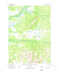
1954 Map of Lake Clark C-6
USGS Topo · Published 1975About this map
The Mulchatna River and Chilikadrotna River dominate this interior Alaskan wilderness, revealing a landscape defined by an intricate network of glacial melt and alpine drainage. Mapped from aerial photographs taken between 1953 and 1957, the terrain is anchored by Marys Mountain, which rises between the river valleys. The hydrology of the region is exceptionally detailed, showing the convergence of Big Bonanza Creek and Bonanza Creek as they feed into the larger river systems. In the southern portion of the sheet, the Chilchitna River and Dummy Creek flow through unsurveyed lands, with locations predetermined by the Bureau of Land Management. This survey captures the remote character of the Seward Meridian before significant modern encroachment, preserving the original hydrographic patterns and landform names used by early 20th-century surveyors and field annotators.
Find a feature on this map
8 named features on this map. Tap any name to fly to it.
Don’t see what you’re looking for? This feature index may not catch every label — zoom into the map to look around manually.
Map Details
Editions of this 1954 Lake Clark C-6 Map
2 editions found
Other maps of this area

1946 · Lake Clark
USGS Topo · 1:250,000

1951 · Lake Clark
USGS Topo · 1:250,000

1954 · Lake Clark C-7
USGS Topo · 1:63,360

1954 · Lake Clark C-6
USGS Topo · 1:63,360

1954 · Lake Clark D-7
USGS Topo · 1:63,360

1954 · Lake Clark B-5
USGS Topo · 1:63,360

1954 · Lake Clark D-5
USGS Topo · 1:63,360

1954 · Lake Clark C-5
USGS Topo · 1:63,360

1954 · Lake Clark B-6
USGS Topo · 1:63,360
1954 · Lake Clark B-7
USGS Topo · 1:63,360