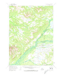
1954 Map of Lake Clark C-7
USGS Topo · Published 1973About this map
The Chilikadrotna River and the Mulchatna River converge in this remote Alaska landscape, creating a complex network of braids and bars that define the region's hydrology. Mapped by the Army Map Service based on aerial photography from the mid-1950s, the terrain is marked by significant elevation changes and numerous unnamed water bodies. Human presence is exceptionally sparse, indicated only by a single Cabin located along the banks of the Mulchatna. This isolate structure, along with the paths of Big Bonanza Creek and Dummy Creek, suggests a landscape used primarily for seasonal trapping, hunting, or early exploratory transit rather than permanent settlement. The survey highlights the raw, unsurveyed nature of the Alaskan interior during this period of territorial transition.
Find a feature on this map
5 named features on this map. Tap any name to fly to it.
Don’t see what you’re looking for? This feature index may not catch every label — zoom into the map to look around manually.
Map Details
Editions of this 1954 Lake Clark C-7 Map
2 editions found
Other maps of this area

1946 · Lake Clark
USGS Topo · 1:250,000

1951 · Lake Clark
USGS Topo · 1:250,000

1954 · Lake Clark C-7
USGS Topo · 1:63,360

1954 · Lake Clark C-6
USGS Topo · 1:63,360

1954 · Lake Clark C-8
USGS Topo · 1:63,360

1954 · Lake Clark D-8
USGS Topo · 1:63,360

1954 · Lake Clark D-7
USGS Topo · 1:63,360

1954 · Lake Clark B-6
USGS Topo · 1:63,360
1954 · Lake Clark B-8
USGS Topo · 1:63,360
1954 · Lake Clark B-7
USGS Topo · 1:63,360