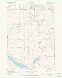
1967 Map of Lake Hanska East
USGS Topo · Published 1968About this map
The sprawling waters of Lake Hanska and the adjacent Omsrud Lake dominate this mid-century portrait of Brown County, Minnesota. This is a landscape of extensive agricultural drainage, marked by a complex network of man-made waterways including Judicial Ditch No 10, County Ditch No 11, and Co Ditch No 58. The Little Cottonwood River meanders through the northern section, while the southern reaches reveal a community centered around rural institutions.
Find a feature on this map
20 named features on this map. Tap any name to fly to it.
Don’t see what you’re looking for? This feature index may not catch every label — zoom into the map to look around manually.
Map Details
Editions of this 1967 Lake Hanska East Map
2 editions found
Other maps of this area

1953 · New Ulm
USGS Topo · 1:250,000

1957 · New Ulm
USGS Topo · 1:250,000

1958 · New Ulm
USGS Topo · 1:250,000

1964 · New Ulm
USGS Topo · 1:24,000

1964 · Sleepy Eye
USGS Topo · 1:24,000

1964 · Essig
USGS Topo · 1:24,000

1965 · Madelia
USGS Topo · 1:24,000

1965 · Hanska
USGS Topo · 1:24,000

1967 · New Ulm
USGS Topo · 1:250,000

1967 · Lake Hanska West
USGS Topo · 1:24,000