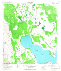
1953 Map of Lake Hatchineha
USGS Topo · Published 1968About this map
Lake Hatchineha anchors this central Florida landscape, where the boundary between Osceola and Polk Counties cuts through a complex network of wetlands and creeks. The hydrology of the early 1950s is meticulously captured, showing the convergence of Reedy Creek and London Creek into the lake's northern reaches. A singular Gaging Station on the shoreline indicates the importance of water level monitoring in this era of regional drainage management.
Find a feature on this map
11 named features on this map. Tap any name to fly to it.
Don’t see what you’re looking for? This feature index may not catch every label — zoom into the map to look around manually.
Map Details
Editions of this 1953 Lake Hatchineha Map
4 editions found
Other maps of this area

1952 · Lake Wales
USGS Topo · 1:24,000

1952 · Lake Weohyakapka NE
USGS Topo · 1:24,000

1952 · Hesperides
USGS Topo · 1:24,000

1953 · Cypress Lake
USGS Topo · 1:24,000

1953 · Dundee
USGS Topo · 1:24,000

1953 · Lake Hatchineha
USGS Topo · 1:24,000

1953 · St Cloud South
USGS Topo · 1:24,000

1953 · Lake Tohopekaliga
USGS Topo · 1:24,000

1953 · Davenport
USGS Topo · 1:24,000

1955 · Orlando
USGS Topo · 1:250,000