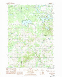
1984 Map of Lake
USGS Topo · Published 1984About this map
Eight Point Lake and Crooked Lake dominate the northern landscape of this region during the mid-1980s, where three counties—Clare, Osceola, and Isabella—intersect. The area serves as a significant recreational and residential hub, evidenced by the presence of Camp Neyati and numerous private air facilities like the Rocky Pine Landing Strip and Scotts Landing Strip. The settlement of Brinton sits to the east, acting as a local focal point near the Isabella county line.
Find a feature on this map
56 named features on this map. Tap any name to fly to it.
Don’t see what you’re looking for? This feature index may not catch every label — zoom into the map to look around manually.
Map Details
Editions of this 1984 Lake Map
This is the sole edition of this map. No revisions or reprints were ever made.
Other maps of this area

1916 · Mount Pleasant
USGS Topo · 1:62,500

1919 · Mount Pleasant
USGS Topo · 1:62,500

1943 · Mount Pleasant
USGS Topo · 1:62,500

1954 · Midland
USGS Topo · 1:250,000

1958 · Midland
USGS Topo · 1:250,000

1959 · Midland
USGS Topo · 1:250,000

1959 · Lake
USGS Topo · 1:62,500

1959 · Clare
USGS Topo · 1:62,500

1964 · Mecosta NW
USGS Topo · 1:24,000

1964 · Sherman City
USGS Topo · 1:24,000