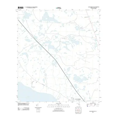
2012 Map of Lake Marian NE
USGS Topo · Published 2012About this map
Lake Marian Highlands sits at the southern edge of this Central Florida landscape, where residential planning meets a vast network of wetlands and cattle operations. The northern shores of Lake Marian are defined by numerous small water bodies and drainage features, including Island Pond, Arnold Pond, and the winding Jerdon Tyner Slough. This region of Osceola County is characterized by large agricultural holdings and named outposts such as Simmons Ranch, Lucky L Ranch, and Rattlesnake Ranch, which suggest a long-standing tradition of ranching and hunting. In the eastern corridor, the settlement of Nittaw serves as a small waypoint near the headwaters of Pagett Br and Tyson Cr, illustrating the sparse but deliberate distribution of homesteads across this interior terrain. The road network, including N Canoe Creek Rd, connects these remote locales to the emerging subdivisions at the lakefront.
Find a feature on this map
25 named features on this map. Tap any name to fly to it.
Don’t see what you’re looking for? This feature index may not catch every label — zoom into the map to look around manually.
Map Details
Editions of this 2012 Lake Marian NE Map
This is the sole edition of this map. No revisions or reprints were ever made.
Other maps of this area

1953 · Lake Marian NW
USGS Topo · 1:24,000

1953 · Lake Marian SE
USGS Topo · 1:24,000

1953 · Holopaw SE
USGS Topo · 1:24,000

1953 · Kenansville SW
USGS Topo · 1:24,000

1953 · Lake Marian SW
USGS Topo · 1:24,000

1953 · Kenansville
USGS Topo · 1:24,000

1953 · Holopaw SW
USGS Topo · 1:24,000

1953 · Deer Park
USGS Topo · 1:24,000

1953 · Lake Marian NE
USGS Topo · 1:24,000

1955 · Orlando
USGS Topo · 1:250,000