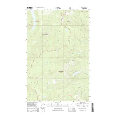
2017 Map of Lake Marshall
USGS Topo · Published 2017About this map
Flathead National Forest and Lolo National Forest converge in this high-elevation region of Missoula County, where the headwaters of the Swan River and the W Fork Clearwater River drain opposing sides of the continental divide. The landscape is dominated by steep timbered ridges and alpine summits such as Sunset Peak and Mount Henry, reflecting a wilderness defined by its complex drainage network. A network of forest roads, including Colt Lake Rd and Marshall Lake Rd, provides the primary access points for this backcountry. Lake Marshall sits as a primary hydrological feature near the center of the sheet, feeding into Marshall Cr. The map preserves the 2017 boundaries and land management divisions between these two major national forests, documenting the protected status of the peaks and river forks that define the northern Rockies.
Find a feature on this map
23 named features on this map. Tap any name to fly to it.
Don’t see what you’re looking for? This feature index may not catch every label — zoom into the map to look around manually.
Map Details
Editions of this 2017 Lake Marshall Map
This is the sole edition of this map. No revisions or reprints were ever made.
Other maps of this area

1921 · Elbow Lake
USGS Topo · 1:125,000

1955 · Choteau
USGS Topo · 1:250,000

1957 · Choteau
USGS Topo · 1:250,000

1958 · Choteau
USGS Topo · 1:250,000

1962 · Choteau
USGS Topo · 1:250,000

1965 · Upper Jocko Lake
USGS Topo · 1:24,000
1965 · Belmore Sloughs
USGS Topo · 1:24,000

1965 · Holland Lake
USGS Topo · 1:24,000

1965 · Seeley Lake West
USGS Topo · 1:24,000

1965 · Gray Wolf Lake
USGS Topo · 1:24,000