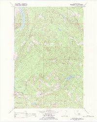
1989 Map of Lake Marshall
USGS Topo · Published 1989About this map
The Flathead Indian Reservation boundary defines the high-altitude landscape of this 1989 survey, where the Mission Mountains Tribal Wilderness meets the protected reaches of the Flathead National Forest. This remote terrain is characterized by a network of glacial lakes and high-relief peaks, including Lindbergh Lake in the northwest and Lake Marshall at the center. The map documents the headwaters of several critical drainages, such as the Swan River and the West Fork Clearwater River, which flow from the steep slopes of the Mission Mountains. The absence of roads is notable, with the area instead being traversed by a series of high-country routes labeled simply as Pack Trail. These trails link remote water bodies like Lake Dinah and Beaver Lake to prominent landmarks like Henry Mount, illustrating the preservation of primitive wilderness and tribal lands in the late 20th century.
Find a feature on this map
22 named features on this map. Tap any name to fly to it.
Don’t see what you’re looking for? This feature index may not catch every label — zoom into the map to look around manually.
Map Details
Editions of this 1989 Lake Marshall Map
This is the sole edition of this map. No revisions or reprints were ever made.
Other maps of this area

1921 · Elbow Lake
USGS Topo · 1:125,000

1955 · Choteau
USGS Topo · 1:250,000

1957 · Choteau
USGS Topo · 1:250,000

1958 · Choteau
USGS Topo · 1:250,000

1962 · Choteau
USGS Topo · 1:250,000

1965 · Upper Jocko Lake
USGS Topo · 1:24,000
1965 · Belmore Sloughs
USGS Topo · 1:24,000

1965 · Holland Lake
USGS Topo · 1:24,000

1965 · Seeley Lake West
USGS Topo · 1:24,000

1965 · Gray Wolf Lake
USGS Topo · 1:24,000