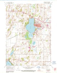
1959 Map of Lake Mills
USGS Topo · Published 1991About this map
Rock Lake dominates this mid-century landscape in Jefferson County, serving as the focal point for the city of Lake Mills. The shoreline is heavily developed with Lakeside Park and a municipal Fish Hatchery, while the surrounding countryside preserves a dense network of nineteenth-century rural institutions. A remarkable concentration of neighborhood schoolhouses, including Plainview Sch, Badger Sch, Brick Street Sch, and Faville Grove Sch, illustrates the late-stage survival of the district school system before widespread consolidation. To the east, the Crawfish R meanders through the township of Milford, where the hamlet of Hoopers Mill stands near the riverbank. Transport is defined by the Chicago and North Western railroad corridor, which cuts through the heart of the region, connecting the lakeside community to the broader agricultural and industrial markets of southern Wisconsin.
Find a feature on this map
39 named features on this map. Tap any name to fly to it.
Don’t see what you’re looking for? This feature index may not catch every label — zoom into the map to look around manually.
Map Details
Editions of this 1959 Lake Mills Map
3 editions found
Other maps of this area

1890 · Sun Prairie
USGS Topo · 1:62,500

1890 · Stoughton
USGS Topo · 1:62,500

1891 · Waterloo
USGS Topo · 1:62,500

1891 · Koshkonong
USGS Topo · 1:62,500

1894 · Waterloo
USGS Topo · 1:62,500

1894 · Koshkonong
USGS Topo · 1:62,500

1896 · Sun Prairie
USGS Topo · 1:62,500

1905 · Sun Prairie
USGS Topo · 1:62,500

1906 · Koshkonong
USGS Topo · 1:62,500

1907 · Sun Prairie
USGS Topo · 1:62,500