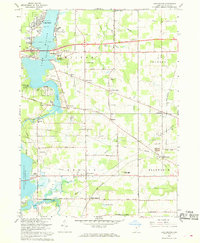
1966 Map of Lake Milton
USGS Topo · Published 1968About this map
Lake Milton and the Mahoning River corridor serve as the primary landmarks in this 1960s study of Mahoning County. The landscape is defined by the juxtaposition of recreational development and rural agricultural heritage, featuring an Amusement Park and Golf Course alongside long-established rural centers like Berlin Center and Smith Corners. The presence of the Penn Central railroad, with stops at Ellsworth Sta and Berlin Center Sta, highlights the enduring importance of rail infrastructure for the small communities and industrial sites, such as the local Gravel Pit and Gas Well. Numerous family-named cemeteries, including Vaughn Cem and Eckis Cem, offer significant research value for genealogists tracing the early residents of Milton and Ellsworth townships. The map also records the transition of the northern shoreline at Craig Beach and Sunset Beach, areas that became focal points for local growth and leisure during the post-war era.
Find a feature on this map
63 named features on this map. Tap any name to fly to it.
Don’t see what you’re looking for? This feature index may not catch every label — zoom into the map to look around manually.
Map Details
Editions of this 1966 Lake Milton Map
2 editions found
Other maps of this area

1906 · Ravenna
USGS Topo · 1:62,500

1908 · Warren
USGS Topo · 1:62,500

1908 · Ravenna
USGS Topo · 1:62,500

1909 · Alliance
USGS Topo · 1:62,500

1909 · Lisbon
USGS Topo · 1:62,500

1950 · Cleveland
USGS Topo · 1:250,000

1951 · Canton
USGS Topo · 1:250,000

1952 · Lake Milton
USGS Topo · 1:24,000

1952 · Canfield
USGS Topo · 1:24,000

1952 · Alliance
USGS Topo · 1:24,000