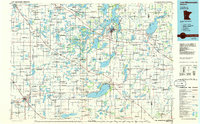
1986 Map of Lake Minnewaska
USGS Topo · Published 1986About this map
Lake Minnewaska anchors this central Minnesota landscape, a region defined by an extensive network of glacial lakes and river systems as they appeared in the mid-1980s. The city of Alexandria serves as a primary hub, surrounded by a dense cluster of water bodies including Lake Darling, Lake Ida, and Lake Carlos State Park. Transportation corridors like Interstate 94 and the Burlington Northern railroad intersect the terrain, connecting smaller agricultural centers such as Starbuck, Glenwood, and Morris. To the south, the Blue Mounds and Glacial Lake State Park highlight the distinct topography of the prairie-forest transition. For the local historian, the map details the intricate drainage patterns of the Chippewa River and the Pomme de Terre River alongside established aviation sites like Alexandria Municipal Airport.
Find a feature on this map
82 named features on this map. Tap any name to fly to it.
Don’t see what you’re looking for? This feature index may not catch every label — zoom into the map to look around manually.
Map Details
Editions of this 1986 Lake Minnewaska Map
2 editions found
Other maps of this area

1910 · Wendell
USGS Topo · 1:62,500

1910 · Chokio
USGS Topo · 1:62,500

1911 · Barrett
USGS Topo · 1:62,500

1911 · Herman
USGS Topo · 1:62,500

1912 · Chokio
USGS Topo · 1:62,500

1912 · Morris
USGS Topo · 1:62,500

1913 · Ashby
USGS Topo · 1:62,500

1913 · Wendell
USGS Topo · 1:62,500

1953 · Milbank
USGS Topo · 1:250,000

1953 · Fargo
USGS Topo · 1:250,000