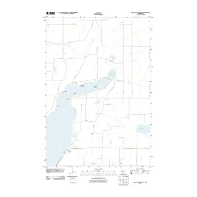
2010 Map of Lake Osakis East
USGS Topo · Published 2010About this map
Little Lake Osakis and the eastern shoreline of Lake Osakis define this central Minnesota landscape, where the waters of the Long Prairie River and Sauk River originate. The terrain is marked by distinct peninsulas like Battle Point, Caughren Point, and Lindberg Point that reach into the main lake body. Settlement patterns here are characterized by a grid of county highways and local roads serving rural homesteads and recreational sites like Linwood Resort and Campground. Local history and genealogy are anchored by several established burial grounds, including Gordon Cemetery near the lake's edge, Stallcop Cemetery further inland, and Salem Cemetery to the south. Smaller water bodies such as Platt Lake, Marge Lake, and Beim Lake dot the countryside, reflecting the glacial topography of the region. This 2010 survey provides a modern view of the area's rural road network, connecting long-standing family farms and lakefront properties.
Find a feature on this map
49 named features on this map. Tap any name to fly to it.
Don’t see what you’re looking for? This feature index may not catch every label — zoom into the map to look around manually.
Map Details
Editions of this 2010 Lake Osakis East Map
This is the sole edition of this map. No revisions or reprints were ever made.
Other maps of this area

1953 · Brainerd
USGS Topo · 1:250,000

1953 · Saint Cloud
USGS Topo · 1:250,000

1957 · Brainerd
USGS Topo · 1:250,000

1957 · Saint Cloud
USGS Topo · 1:250,000

1958 · Saint Cloud
USGS Topo · 1:250,000

1958 · Brainerd
USGS Topo · 1:250,000

1965 · Brainerd
USGS Topo · 1:250,000

1966 · West Union
USGS Topo · 1:24,000

1966 · Osakis
USGS Topo · 1:24,000
1966 · Sauk Lake
USGS Topo · 1:24,000