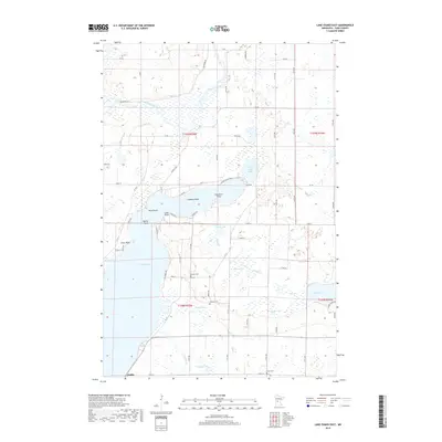
2019 Map of Lake Osakis East
USGS Topo · Published 2019About this map
The eastern shores of Lake Osakis define this Central Minnesota landscape, where the town of Osakis sits at the southern tip of the water. The terrain is a complex network of wetlands and smaller basins, including Platt Lake, Little Lake Osakis, and Slanson Lake, connected by the winding course of the Long Prairie River and the Sauk River. These waterways have long shaped the local geography, creating distinctive landforms such as Battle Point, Lindberg Point, and Caughren Point that reach into the main lake.
Find a feature on this map
69 named features on this map. Tap any name to fly to it.
Don’t see what you’re looking for? This feature index may not catch every label — zoom into the map to look around manually.
Map Details
Editions of this 2019 Lake Osakis East Map
This is the sole edition of this map. No revisions or reprints were ever made.
Other maps of this area

1953 · Brainerd
USGS Topo · 1:250,000

1953 · Saint Cloud
USGS Topo · 1:250,000

1957 · Brainerd
USGS Topo · 1:250,000

1957 · Saint Cloud
USGS Topo · 1:250,000

1958 · Saint Cloud
USGS Topo · 1:250,000

1958 · Brainerd
USGS Topo · 1:250,000

1965 · Brainerd
USGS Topo · 1:250,000

1966 · West Union
USGS Topo · 1:24,000

1966 · Osakis
USGS Topo · 1:24,000
1966 · Sauk Lake
USGS Topo · 1:24,000