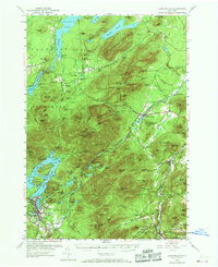
1953 Map of Lake Placid
USGS Topo · Published 1969About this map
Whiteface Mtn dominates the center of this High Peaks landscape, which in the early 1950s was already becoming a major hub for tourism and recreation. The Whiteface Mtn Memorial Highway and Wilmington Toll Road snake up the slopes, while the settlement of Lake Placid sits to the south near its namesake lake and Mirror Lake. Significant local history is anchored at the John Browns Grave historic site and numerous family-named burial grounds like Malbone Cem and Davis Cem. Industrial echoes remain in the form of charcoal or lime production sites at Middle Kilns and West Kilns, contrasting with the whimsical mid-century development of North Pole near Wilmington. The map captures a moment of transition where old Adirondack settlements like Franklin Falls and Keene coexist with an expanding infrastructure of ski trails and a Municipal Airport.
Find a feature on this map
105 named features on this map. Tap any name to fly to it.
Don’t see what you’re looking for? This feature index may not catch every label — zoom into the map to look around manually.
Map Details
Editions of this 1953 Lake Placid Map
4 editions found

Other maps of this area

1894 · Elizabethtown
USGS Topo · 1:62,500

1895 · Elizabethtown
USGS Topo · 1:62,500

1895 · Mt. Marcy
USGS Topo · 1:62,500

1895 · Ausable
USGS Topo · 1:62,500

1896 · Lake Placid
USGS Topo · 1:62,500

1898 · Lake Placid
USGS Topo · 1:62,500

1901 · Elizabethtown
USGS Topo · 1:62,500

1902 · Mt. Marcy
USGS Topo · 1:62,500

1902 · Saranac
USGS Topo · 1:62,500

1903 · Ausable
USGS Topo · 1:62,500