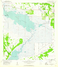
1953 Map of Lake Poinsett
USGS Topo · Published 1961About this map
The St Johns River winds through a landscape of expansive wetlands and interconnected lakes, defining the eastern Florida interior in the early 1950s. This survey, compiled from 1951 aerial photography, documents a period before significant modern development altered the marshy corridor between Lake Poinsett and Lake Winder. Settlement is concentrated at small outposts like Lone Cabbage Camp in the north and Poinsett Lodge along the lake's edge, while the eastern margin shows the early footprint of Rockledge. The map illustrates a complex water management system of the era, including numerous levee structures, the Faulk Canal, and several noted flowing wells. Cultural landmarks like Mulberry Mound and Pine Crest Cem provide specific points of interest for local history and genealogy, highlighting early human presence within the St. Johns floodplain.
Find a feature on this map
19 named features on this map. Tap any name to fly to it.
Don’t see what you’re looking for? This feature index may not catch every label — zoom into the map to look around manually.
Map Details
Editions of this 1953 Lake Poinsett Map
4 editions found
Other maps of this area

1949 · Courtenay
USGS Topo · 1:24,000

1949 · Eau Gallie
USGS Topo · 1:24,000

1949 · Sharpes
USGS Topo · 1:24,000

1949 · Cocoa
USGS Topo · 1:24,000

1951 · Eau Gallie
USGS Topo · 1:24,000

1951 · Cocoa
USGS Topo · 1:24,000

1951 · Courtenay
USGS Topo · 1:24,000

1951 · Sharpes
USGS Topo · 1:24,000

1953 · Lake Poinsett
USGS Topo · 1:24,000

1953 · Deer Park NE
USGS Topo · 1:24,000