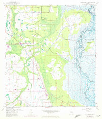
1953 Map of Lake Poinsett NW
USGS Topo · Published 1972About this map
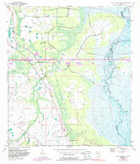
The St Johns River meanders through a labyrinth of marshlands and wetlands along the border of Orange and Brevard counties in this early 1950s survey. The landscape is defined by vast natural drainage patterns, with Second Creek, Jim Creek, and Sweetwater Branch feeding into the river system. Elevated ground appears as distinct landmarks like Long Bluff and Possum Bluff, which stand out against the surrounding low-lying terrain.
Find a feature on this map
13 named features on this map. Tap any name to fly to it.
Don’t see what you’re looking for? This feature index may not catch every label — zoom into the map to look around manually.
Map Details
Editions of this 1953 Lake Poinsett NW Map
6 editions found
Other maps of this area

1949 · Titusville
USGS Topo · 1:24,000

1949 · Sharpes
USGS Topo · 1:24,000

1951 · Sharpes
USGS Topo · 1:24,000

1952 · Titusville
USGS Topo · 1:24,000

1953 · Lake Poinsett
USGS Topo · 1:24,000

1953 · Narcoossee NE
USGS Topo · 1:24,000

1953 · Narcoossee SE
USGS Topo · 1:24,000

1953 · Lake Poinsett SW
USGS Topo · 1:24,000

1953 · Titusville SW
USGS Topo · 1:24,000

1953 · Lake Poinsett NW
USGS Topo · 1:24,000