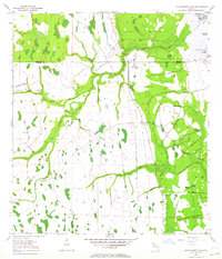
1953 Map of Lake Poinsett SW
USGS Topo · Published 1964About this map
The St Johns River floodplain dominates this mid-century landscape at the intersection of Osceola, Orange, and Brevard counties. The terrain is defined by a complex network of waterways, including the North Fork and South Fork of the St Johns, along with smaller tributaries like Beef Camp Branch and Gator Branch. Human activity is marked by cattle ranching and early infrastructure, most notably at the K6 Ranch and the long stretches of Old Railroad Grade that traverse the marshy lowlands. Several Flowing Well sites are noted near the river and the Spoil Bank and Levee systems, which suggest early water management efforts in the region. To the northeast, the map shows the edge of Lake Poinsett and the Mulberry Mound, a distinct topographical feature in the wet prairie landscape. Significant watercourses such as Taylor Creek and Cox Creek flow toward the main river channel, illustrating the natural drainage patterns before modern development altered the Florida interior.
Find a feature on this map
21 named features on this map. Tap any name to fly to it.
Don’t see what you’re looking for? This feature index may not catch every label — zoom into the map to look around manually.
Map Details
Editions of this 1953 Lake Poinsett SW Map
5 editions found
Other maps of this area

1949 · Sharpes
USGS Topo · 1:24,000

1951 · Sharpes
USGS Topo · 1:24,000

1953 · Lake Poinsett
USGS Topo · 1:24,000

1953 · Deer Park NE
USGS Topo · 1:24,000

1953 · Narcoossee NE
USGS Topo · 1:24,000

1953 · Narcoossee SE
USGS Topo · 1:24,000

1953 · Deer Park NW
USGS Topo · 1:24,000

1953 · Lake Poinsett SW
USGS Topo · 1:24,000

1953 · Holopaw
USGS Topo · 1:24,000

1953 · Lake Poinsett NW
USGS Topo · 1:24,000