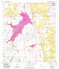
1953 Map of Lake Poinsett SW
USGS Topo · Published 1981About this map
Taylor Creek and its many meandering tributaries define this landscape along the border of Osceola, Orange, and Brevard counties in the early 1950s. The terrain is a complex network of wetlands and drainage features, including the North Fork and South Fork which feed into larger systems near Lake Poinsett. Revisions from late 1970s aerial photography highlight significant land use changes, particularly the development of expansive water management features like the Levee and various sections labeled Spoil Bank.
Find a feature on this map
21 named features on this map. Tap any name to fly to it.
Don’t see what you’re looking for? This feature index may not catch every label — zoom into the map to look around manually.
Map Details
Editions of this 1953 Lake Poinsett SW Map
5 editions found
Other maps of this area

1949 · Sharpes
USGS Topo · 1:24,000

1951 · Sharpes
USGS Topo · 1:24,000

1953 · Lake Poinsett
USGS Topo · 1:24,000

1953 · Deer Park NE
USGS Topo · 1:24,000

1953 · Narcoossee NE
USGS Topo · 1:24,000

1953 · Narcoossee SE
USGS Topo · 1:24,000

1953 · Deer Park NW
USGS Topo · 1:24,000

1953 · Lake Poinsett SW
USGS Topo · 1:24,000

1953 · Holopaw
USGS Topo · 1:24,000

1953 · Lake Poinsett NW
USGS Topo · 1:24,000