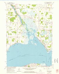
1961 Map of Lake Poygan
USGS Topo · Published 1977About this map
Wolf River and the sprawling waters of Lake Poygan dominate this mid-century survey of eastern Waupaca and Winnebago Counties. The landscape is defined by the complex aquatic network of Pages Slough, Boom Bay, and Norwegian Bay, where the river meets the lake. Small communities like Zittau and Orihula serve as anchors for the surrounding rural area, which is dotted with localized social institutions including Immanuel Ch, Zion Ch, and the Wolf River Sch. Genealogists will find significant value in the documentation of several family and community burial sites, such as Becker Cem, St Pauls Cem, and Wolf River Cem. The map illustrates the region just as modern updates were being noted, with purple revisions from 1975 showing shifts in development around the Trailer Park and along the shores of Lake Winneconne.
Find a feature on this map
34 named features on this map. Tap any name to fly to it.
Don’t see what you’re looking for? This feature index may not catch every label — zoom into the map to look around manually.
Map Details
Editions of this 1961 Lake Poygan Map
2 editions found
Other maps of this area

1955 · Green Bay
USGS Topo · 1:250,000

1956 · New London
USGS Topo · 1:48,000

1956 · Weyauwega
USGS Topo · 1:48,000

1961 · Poy Sippi
USGS Topo · 1:62,500

1961 · Oshkosh
USGS Topo · 1:62,500

1961 · Lake Poygan
USGS Topo · 1:24,000
1961 · Auroraville
USGS Topo · 1:24,000

1961 · Oshkosh NW
USGS Topo · 1:24,000
1961 · Eureka
USGS Topo · 1:24,000
1961 · Omro
USGS Topo · 1:24,000