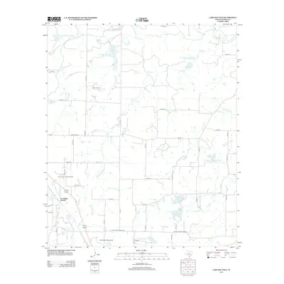
2013 Map of Lake San Tana
USGS Topo · Published 2013About this map
San Angelo Junction sits at a crossroads of ranching and industry in this portion of Coleman County. The landscape is defined by its transition from the rolling drainage of Watts Cr and Mukewater Cr toward the prominent elevations of the Santa Anna Mountains to the south. This area demonstrates a mid-century commitment to land management and water security, evidenced by a series of engineered water bodies including the Soil Conservation Service Site 31 Reservoir and several numbered sites along the watershed. The local economy is visibly anchored in petroleum extraction, with the Hagler Oil Field and Coleman Junction North Oil Field marking the subterranean resources of the region. Recreational and municipal water features like Lake San Tana and Lake Sealy provide a contrast to the surrounding network of county roads and grazing lands.
Find a feature on this map
46 named features on this map. Tap any name to fly to it.
Don’t see what you’re looking for? This feature index may not catch every label — zoom into the map to look around manually.
Map Details
Editions of this 2013 Lake San Tana Map
This is the sole edition of this map. No revisions or reprints were ever made.
Other maps of this area

1887 · Coleman
USGS Topo · 1:125,000

1889 · Coleman
USGS Topo · 1:125,000

1924 · Brownwood Reservoir Site
USGS Topo · 1:48,000

1927 · Grosvenor
USGS Topo · 1:62,500

1954 · Brownwood
USGS Topo · 1:250,000

1960 · Lake Scarborough
USGS Topo · 1:24,000
1960 · Coleman NE
USGS Topo · 1:24,000
1960 · Burkett
USGS Topo · 1:24,000

1962 · Santa Anna
USGS Topo · 1:24,000
1962 · Bangs West
USGS Topo · 1:24,000