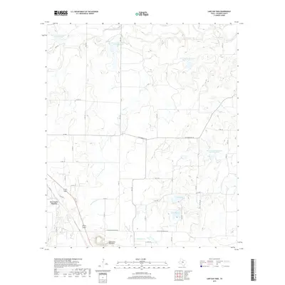
2019 Map of Lake San Tana
USGS Topo · Published 2019About this map
San Angelo Junction sits at the southwestern edge of this 2019 survey, serving as a focal point for the local transportation network in Coleman County. The landscape is defined by the prominent Santa Anna Mountains rising in the south, where N Santa Anna Mountain Rd winds along the base of the peaks. This area of Texas is characterized by a managed water system, featuring numerous reservoirs such as Lake San Tana and Lake Sealy, alongside several Soil Conservation Service sites that regulate the seasonal flow of Watts Cr and Mud Cr. The presence of Old Comanche Rd suggests a historical transit corridor that persists into the modern era, cutting across a terrain etched by the intermittent drainages of Santa Anna Br and Mukewater Cr. The map details a dense grid of county roads that provide access to the rural ranching and agricultural lands between these water bodies.
Find a feature on this map
44 named features on this map. Tap any name to fly to it.
Don’t see what you’re looking for? This feature index may not catch every label — zoom into the map to look around manually.
Map Details
Editions of this 2019 Lake San Tana Map
This is the sole edition of this map. No revisions or reprints were ever made.
Other maps of this area

1887 · Coleman
USGS Topo · 1:125,000

1889 · Coleman
USGS Topo · 1:125,000

1924 · Brownwood Reservoir Site
USGS Topo · 1:48,000

1927 · Grosvenor
USGS Topo · 1:62,500

1954 · Brownwood
USGS Topo · 1:250,000

1960 · Lake Scarborough
USGS Topo · 1:24,000
1960 · Coleman NE
USGS Topo · 1:24,000
1960 · Burkett
USGS Topo · 1:24,000

1962 · Santa Anna
USGS Topo · 1:24,000
1962 · Bangs West
USGS Topo · 1:24,000