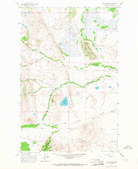
1958 Map of Lake Theboe
USGS Topo · Published 1967About this map
Pine Butte stands as a prominent landmark in this Teton County landscape, where the drainage systems of North Fork Willow Creek and South Fork Willow Creek define the ranching territory. The map captures the area just as the mid-century period was ending, documenting a network of established homesteads including Bowman Ranch, Durr Ranch, and Salmond Ranch.
Find a feature on this map
24 named features on this map. Tap any name to fly to it.
Don’t see what you’re looking for? This feature index may not catch every label — zoom into the map to look around manually.
Map Details
Editions of this 1958 Lake Theboe Map
2 editions found
Other maps of this area

1903 · Saypo
USGS Topo · 1:125,000

1920 · Choteau
USGS Topo · 1:125,000

1955 · Choteau
USGS Topo · 1:250,000

1957 · Choteau
USGS Topo · 1:250,000

1958 · Choteau
USGS Topo · 1:250,000

1958 · Ear Mountain
USGS Topo · 1:24,000

1958 · Lake Theboe
USGS Topo · 1:24,000

1958 · Cave Mountain
USGS Topo · 1:24,000
1958 · Twin Lakes
USGS Topo · 1:24,000

1958 · Castle Reef
USGS Topo · 1:24,000