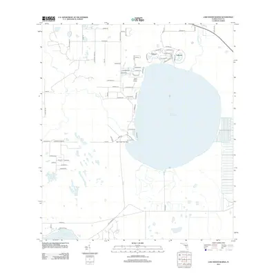
2012 Map of Lake Weohyakapka
USGS Topo · Published 2012About this map
Lake Weohyakapka dominates this landscape in eastern Polk County, serving as a focal point for the surrounding residential and natural areas. Along its northern shores, the distinct retirement communities of Nalcrest and Fedhaven are visible, featuring dense street networks like Fedhaven Cir and Leisure Ln E. These developments contrast sharply with the southern and western portions of the map, which are characterized by more sparse rural infrastructure and substantial natural features. The Tiger Creek Hammock and various water bodies, including Lake Aurora and Tiger Cr, suggest a region defined by its hydrography and wetlands. Local transportation and private infrastructure are noted by unique markers such as David Wine's Airstrip and numerous rural thoroughfares like Rattlesnake Rd and Dogyard Rd.
Find a feature on this map
69 named features on this map. Tap any name to fly to it.
Don’t see what you’re looking for? This feature index may not catch every label — zoom into the map to look around manually.
Map Details
Editions of this 2012 Lake Weohyakapka Map
This is the sole edition of this map. No revisions or reprints were ever made.
Other maps of this area

1952 · Lake Wales
USGS Topo · 1:24,000

1952 · Lake Weohyakapka SE
USGS Topo · 1:24,000

1952 · Lake Weohyakapka NE
USGS Topo · 1:24,000

1952 · Lake Arbuckle NE
USGS Topo · 1:24,000

1952 · Babson Park
USGS Topo · 1:24,000

1952 · Hesperides
USGS Topo · 1:24,000

1952 · Lake Arbuckle
USGS Topo · 1:24,000

1952 · Lake Weohyakapka
USGS Topo · 1:24,000

1953 · Frostproof
USGS Topo · 1:24,000

1956 · Fort Pierce
USGS Topo · 1:250,000