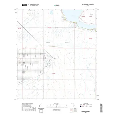
2021 Map of Lake Weohyakapka SE
USGS Topo · Published 2021About this map
Indian Lake Estates occupies the western portion of this Central Florida landscape, defined by an intricate grid of streets named for tropical flora including Poinciana Dr, Hibiscus Dr, and Calendula Dr. This residential development sits atop the transition from the upland sand ridges of Polk County toward the extensive wetlands of the Kissimmee River basin. To the northeast, the shoreline of Lake Kissimmee dominates the terrain, featuring the prominent landmass of Brahma Island and the shallow waters of Thomas Shoal. The southeastern corner of the map reveals the complex hydrology of the region before it reaches the Kissimmee River, with multiple drainages such as Buttermilk Slough and Buckingham Slough cutting through the lowlands. Extensive marshy areas like Blue Jordan Swamp illustrate the natural state of this landscape that persists alongside 21st-century residential expansion.
Find a feature on this map
55 named features on this map. Tap any name to fly to it.
Don’t see what you’re looking for? This feature index may not catch every label — zoom into the map to look around manually.
Map Details
Editions of this 2021 Lake Weohyakapka SE Map
This is the sole edition of this map. No revisions or reprints were ever made.
Other maps of this area

1952 · Lake Weohyakapka SE
USGS Topo · 1:24,000

1952 · Lake Weohyakapka NE
USGS Topo · 1:24,000

1952 · Fort Kissimmee NW
USGS Topo · 1:24,000

1952 · Lake Arbuckle NE
USGS Topo · 1:24,000

1952 · Hesperides
USGS Topo · 1:24,000

1952 · Lake Arbuckle
USGS Topo · 1:24,000

1952 · Lake Weohyakapka
USGS Topo · 1:24,000

1953 · Lake Marian NW
USGS Topo · 1:24,000

1953 · Lake Marian SW
USGS Topo · 1:24,000

1956 · Fort Pierce
USGS Topo · 1:250,000