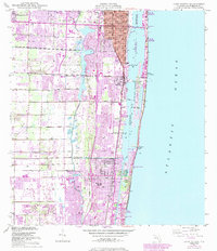
1945 Map of Lake Worth
USGS Topo · Published 1983About this map
The coastal corridor of Palm Beach County is defined here by the parallel lines of the Intracoastal Waterway and the Atlantic Ocean, creating a narrow strip of barrier island development. Between the mid-1940s and the early 1980s, the region transitioned from a series of distinct coastal settlements into a continuous urban landscape. The map captures the infrastructure of this growth, including Florida's Turnpike and major rail lines like the Florida East Coast and the Seaboard Coast Line. Significant inland water bodies like Lake Osborne are buffered by recreational spaces such as John Prince Park, while the coastal geography is marked by the Boynton Inlet and the prominent Hypoluxo Island. This survey documents the mid-century expansion of towns such as Lake Worth, Lantana, and Boynton Beach before they fully merged into the modern South Florida megalopolis.
Find a feature on this map
35 named features on this map. Tap any name to fly to it.
Don’t see what you’re looking for? This feature index may not catch every label — zoom into the map to look around manually.
Map Details
Editions of this 1945 Lake Worth Map
4 editions found
Other maps of this area

1945 · Greenacres City
USGS Topo · 1:24,000

1945 · Lake Worth
USGS Topo · 1:24,000

1946 · Palm Beach Farms
USGS Topo · 1:24,000

1946 · Palm Beach
USGS Topo · 1:24,000

1947 · Delmar Farms
USGS Topo · 1:24,000

1949 · Lake Worth
USGS Topo · 1:24,000

1949 · Palm Beach Farms
USGS Topo · 1:24,000

1949 · Delmar Farms
USGS Topo · 1:24,000

1950 · Delray Beach
USGS Topo · 1:24,000

1950 · Greenacres City
USGS Topo · 1:24,000