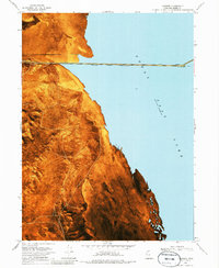
1969 Map of Lakeside
USGS Topo · Published 1985About this map
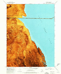
Lakeside Mountains dominate this 1960s landscape, where the high desert terrain of the Hill Air Force Range meets the west coast of the Great Salt Lake. The settlement of Lakeside serves as a critical point on the Southern Pacific (Lucin Cutoff), which stretches across the water toward Tresend. Industrial activity is evident near the shoreline, marked by a Quarry, Borrow Pit, and a Prospect at the base of the buttes. The terrain is characterized by complex ridges and passes, including Gillespie Pass and Fixit Pass, as well as the prominent Cave Ridge. The transition from the steep elevations of The Gillespies to the expansive Mud Flat and the historic Sand Bar illustrates the unique geology of this Box Elder County region.
Find a feature on this map
21 named features on this map. Tap any name to fly to it.
Don’t see what you’re looking for? This feature index may not catch every label — zoom into the map to look around manually.
Map Details
Editions of this 1969 Lakeside Map
2 editions found
Other maps of this area

1954 · Brigham City
USGS Topo · 1:250,000

1958 · Brigham City
USGS Topo · 1:250,000

1962 · Brigham City
USGS Topo · 1:250,000

1968 · Carrington Island SW
USGS Topo · 1:24,000

1968 · Deardens Knoll
USGS Topo · 1:24,000

1969 · Rozel Point SW
USGS Topo · 1:24,000

1969 · Gunnison Island SW
USGS Topo · 1:24,000

1969 · Carrington Island NW
USGS Topo · 1:24,000

1969 · Strongs Knob
USGS Topo · 1:24,000

1969 · Gunnison Island
USGS Topo · 1:24,000