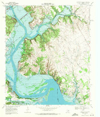
1968 Map of Lakeside Village
USGS Topo · Published 1971About this map
The confluence of the Brazos River and Nolan River dominates this late-1960s survey, illustrating a landscape redefined by the creation of Lake Whitney. The topography reveals the intricate shoreline of the reservoir, where former lowlands like Steiner Valley became subject to controlled inundation, leaving only higher elevations such as the Powelldale Mountains and Robison Bluff as prominent landmarks. The map records the persistence of local heritage through sites like Steiner Valley Cem and Heath Cem, which sit near the shifting water's edge.
Find a feature on this map
42 named features on this map. Tap any name to fly to it.
Don’t see what you’re looking for? This feature index may not catch every label — zoom into the map to look around manually.
Map Details
Editions of this 1968 Lakeside Village Map
2 editions found
Other maps of this area

1888 · Meridian
USGS Topo · 1:125,000

1889 · Granbury
USGS Topo · 1:125,000

1891 · Cleburne
USGS Topo · 1:125,000

1892 · Waco
USGS Topo · 1:125,000

1894 · Meridian
USGS Topo · 1:125,000

1894 · Cleburne
USGS Topo · 1:125,000

1920 · Waco
USGS Topo · 1:125,000

1924 · Cleburne 3-B
USGS Topo · 1:48,000

1924 · Waco 2-b
USGS Topo · 1:48,000

1924 · Cleburne 3-C
USGS Topo · 1:48,000