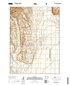
2020 Map of Lakeview Airport
USGS Topo · Published 2020About this map
Lakeview serves as the focal point for this high-desert landscape in Lake County, situated where the valley floor meets the slopes of the Fremont National Forest. The map documents a complex network of water management features essential to the region's agricultural life, including the Baldwin Ditch, Gray Lateral, and the storage at Farleighs Reservoir. These man-made improvements redirect the flow of natural watercourses like Cottonwood Cr and Thomas Cr across the basin floor.
Find a feature on this map
46 named features on this map. Tap any name to fly to it.
Don’t see what you’re looking for? This feature index may not catch every label — zoom into the map to look around manually.
Map Details
Editions of this 2020 Lakeview Airport Map
This is the sole edition of this map. No revisions or reprints were ever made.
Other maps of this area

1955 · Klamath Falls
USGS Topo · 1:250,000

1958 · Klamath Falls
USGS Topo · 1:250,000

1964 · Lakeview NE
USGS Topo · 1:24,000

1964 · Crooked Creek Valley
USGS Topo · 1:24,000

1964 · Lakeview SW
USGS Topo · 1:24,000

1964 · Cox Flat
USGS Topo · 1:24,000

1964 · Lakeview NW
USGS Topo · 1:24,000
1964 · Fitzwater Point
USGS Topo · 1:24,000

1964 · Drews Gap
USGS Topo · 1:24,000
1964 · Crane Creek
USGS Topo · 1:24,000