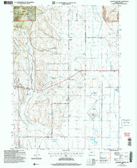
2004 Map of Lakeview Airport
USGS Topo · Published 2007About this map
Fremont National Forest dominates the northwestern corner of this Lake County landscape, where the high desert terrain transitions into the irrigated agricultural lands of the Goose Lake Valley. The central and eastern portions of the map reveal a network of ranching infrastructure and rural development, anchored by the Lakeview Airport and the Warner Creek Correctional Facility. A system of primary irrigation and drainage, including Thomas Creek and Cottonwood Creek, supports the local ranching economy, while historical school sites like the New Idaho School and Vernon Sch reflect the area's educational heritage.
Find a feature on this map
28 named features on this map. Tap any name to fly to it.
Don’t see what you’re looking for? This feature index may not catch every label — zoom into the map to look around manually.
Map Details
Editions of this 2004 Lakeview Airport Map
This is the sole edition of this map. No revisions or reprints were ever made.
Other maps of this area

1955 · Klamath Falls
USGS Topo · 1:250,000

1958 · Klamath Falls
USGS Topo · 1:250,000

1964 · Lakeview NE
USGS Topo · 1:24,000

1964 · Crooked Creek Valley
USGS Topo · 1:24,000

1964 · Lakeview SW
USGS Topo · 1:24,000

1964 · Cox Flat
USGS Topo · 1:24,000

1964 · Lakeview NW
USGS Topo · 1:24,000
1964 · Fitzwater Point
USGS Topo · 1:24,000

1964 · Drews Gap
USGS Topo · 1:24,000
1964 · Crane Creek
USGS Topo · 1:24,000