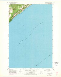
1953 Map of Lakewood
USGS Topo · Published 1970About this map
Lake Superior dominates this mid-century survey, its expansive waters meeting the rocky shoreline of St. Louis County just north of Duluth. The infrastructure of the era is concentrated along the coast, where the Duluth Missabe and Iron Range Railway and North Shore Drive parallel the water, facilitating the region's industrial and residential movement. Near the settlement of Lakewood, a utility network is visible through the presence of a Reservoir and a Pumping Station, while the Lakewood City Boundary marks the extent of local governance at the time.
Find a feature on this map
17 named features on this map. Tap any name to fly to it.
Don’t see what you’re looking for? This feature index may not catch every label — zoom into the map to look around manually.
Map Details
Editions of this 1953 Lakewood Map
4 editions found
Other maps of this area

1895 · Duluth
USGS Topo · 1:62,500

1915 · Superior
USGS Topo · 1:48,000

1917 · Superior
USGS Topo · 1:62,500

1949 · Poplar
USGS Topo · 1:48,000

1953 · Lakewood
USGS Topo · 1:24,000

1953 · French River
USGS Topo · 1:24,000

1953 · Arnold
USGS Topo · 1:24,000

1953 · Duluth
USGS Topo · 1:24,000

1953 · Knife River
USGS Topo · 1:24,000

1953 · Duluth
USGS Topo · 1:62,500