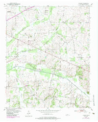
1952 Map of Lambert
USGS Topo · Published 1984About this map
Loosahatchie River and its extensive bottomlands define this portion of Fayette County, where the 1952 landscape is dominated by a systematic network of drainage improvements like the Loosahatchie River Canal and Laurel Creek Canal. The settlement pattern follows the higher ground flanking the Cypress Bottom and Loosahatchie Bottom, revealing a dense distribution of rural institutions essential to mid-century Tennessee life. Small communities and named locales such as Lambert and Moorman are anchored by numerous country schools, including Warren Sch and Brewer Sch, and local churches like Rhea Chapel and Feathers Chapel. For genealogists, the map is particularly valuable for its many family-named landmarks and burial sites, from the Mason Quarter Cem near the northern boundary to the Stafford Cem in the southwest, reflecting the deep-rooted agrarian history of the region before modern consolidation.
Find a feature on this map
36 named features on this map. Tap any name to fly to it.
Don’t see what you’re looking for? This feature index may not catch every label — zoom into the map to look around manually.
Map Details
Editions of this 1952 Lambert Map
2 editions found
Other maps of this area

1943 · Collierville
USGS Topo · 1:62,500

1949 · Moscow
USGS Topo · 1:62,500

1952 · Stanton
USGS Topo · 1:24,000

1952 · Lambert
USGS Topo · 1:24,000

1952 · Dancyville
USGS Topo · 1:24,000

1952 · Laconia
USGS Topo · 1:24,000

1952 · Stanton
USGS Topo · 1:62,500

1953 · Collierville
USGS Topo · 1:50,000

1954 · Mason
USGS Topo · 1:62,500

1956 · Blytheville
USGS Topo · 1:250,000