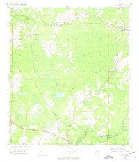
1955 Map of Lamont
USGS Topo · Published 1975About this map
Gress Swamp dominates the central portion of this mid-century survey, a low-lying landscape defined by a network of seasonal watercourses and wetlands on the border of Jefferson and Madison counties. The settlements of Aucilla and Lamont anchor the rail infrastructure of the day, where the Seaboard Air Line and the Atlantic Coast Line traverse the pine-and-cypress terrain.
Find a feature on this map
27 named features on this map. Tap any name to fly to it.
Don’t see what you’re looking for? This feature index may not catch every label — zoom into the map to look around manually.
Map Details
Editions of this 1955 Lamont Map
3 editions found
Other maps of this area

1954 · Greenville
USGS Topo · 1:24,000

1954 · Valdosta
USGS Topo · 1:250,000

1955 · Lamont
USGS Topo · 1:24,000

1955 · Waukeenah
USGS Topo · 1:24,000

1955 · Shady Grove
USGS Topo · 1:24,000

1955 · Lamont SE
USGS Topo · 1:24,000

1955 · Wacissa
USGS Topo · 1:24,000

1958 · Valdosta
USGS Topo · 1:250,000

1959 · Valdosta
USGS Topo · 1:250,000

1962 · Ashville
USGS Topo · 1:24,000