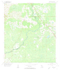
1955 Map of Lamont SE
USGS Topo · Published 1956About this map
The Aucilla River carves a winding path through the lowlands of north Florida, serving as a natural boundary between Jefferson, Madison, and Taylor counties. In the mid-1950s, this landscape was defined by its scattered rural institutions, where small settlements like Lamont and Eridu anchored a network of timber and agricultural interests. The map reveals a dense concentration of family and community landmarks, particularly north of the river near Anderson Bay. Genealogists will find significant value in the numerous burial grounds documented, including Anderson Cem, Walker Cem, and Henderson Cem. The presence of the Atlantic Coast Line railroad and schools like Allison Sch and Green Grove Sch speaks to the established social fabric of the era, while scattered Borrow Pits indicate ongoing infrastructure development in this corner of the Florida panhandle.
Find a feature on this map
20 named features on this map. Tap any name to fly to it.
Don’t see what you’re looking for? This feature index may not catch every label — zoom into the map to look around manually.
Map Details
Editions of this 1955 Lamont SE Map
4 editions found
Other maps of this area

1952 · Secotan
USGS Topo · 1:24,000

1954 · Johnson Hammock
USGS Topo · 1:24,000

1954 · Secotan
USGS Topo · 1:24,000

1954 · Greenville
USGS Topo · 1:24,000

1954 · Valdosta
USGS Topo · 1:250,000

1955 · Lamont
USGS Topo · 1:24,000

1955 · Waukeenah
USGS Topo · 1:24,000

1955 · Shady Grove
USGS Topo · 1:24,000

1955 · Nutall Rise
USGS Topo · 1:24,000

1955 · Lamont SE
USGS Topo · 1:24,000